A next-generation AR-enabled surveying solution for precision fieldwork and mapping efficiency
Introduction to the L1-AR GNSS RTK Survey System
Modern surveying demands accuracy, speed, and intuitive workflows. As industries such as construction, engineering, and land development evolve, professionals require tools that can keep up with increasingly complex environments. The L1-AR GNSS RTK Survey System is designed to meet these expectations by combining high-precision positioning with augmented reality capabilities.
This innovative device is not just a traditional GNSS receiver. It integrates advanced satellite tracking, AR visualization, and intelligent motion sensors to deliver a seamless field experience. With centimeter-level accuracy, fast initialization, and support for multiple global satellite systems, it provides a reliable solution for both experienced surveyors and professionals transitioning to modern digital workflows.
In this in-depth review, we will explore its features, specifications, performance, and practical applications. Whether you are involved in topographic surveys, construction layout, or infrastructure projects, this guide will help you understand how this RTK system can transform your workflow.
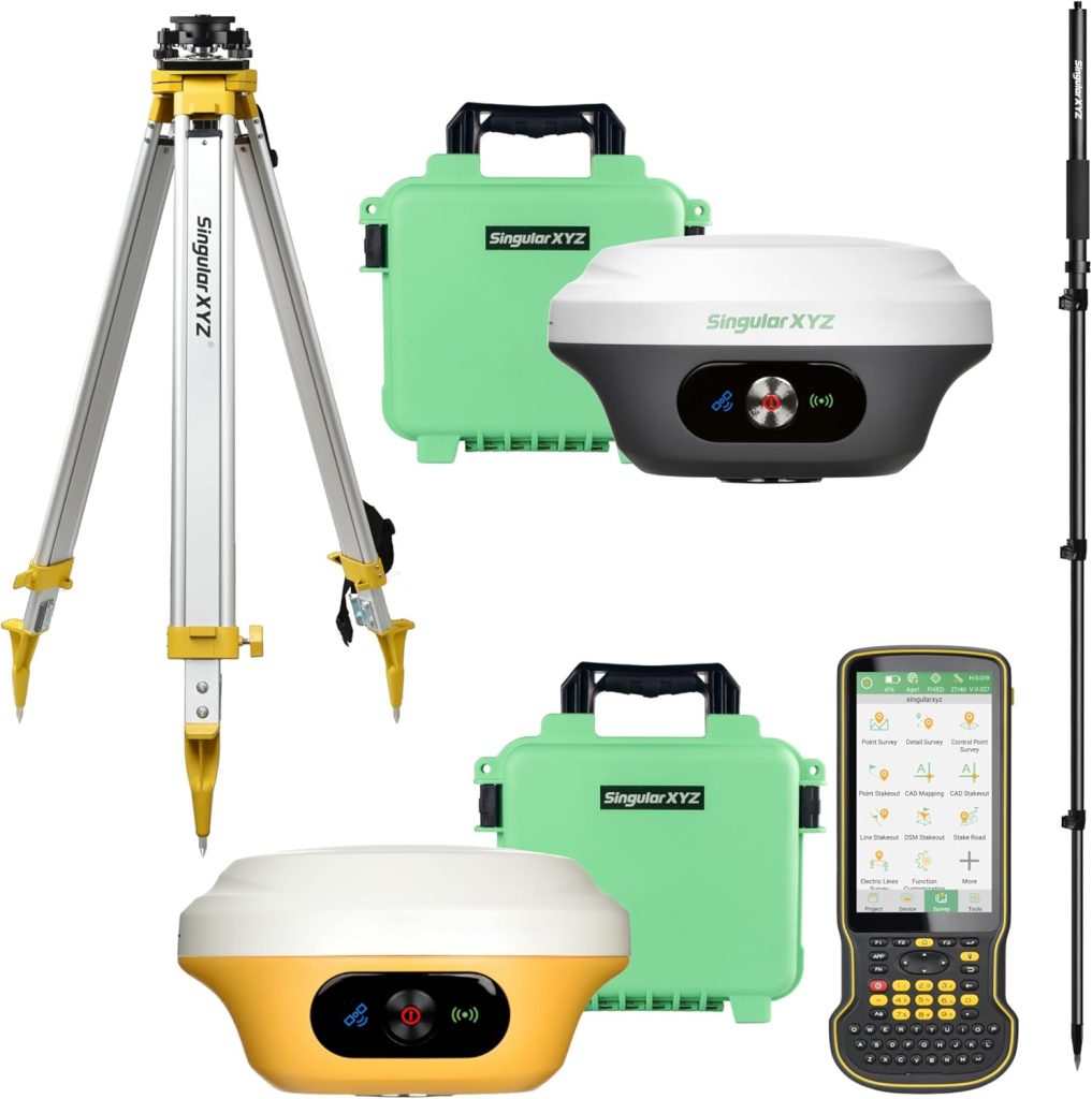
Product Overview and Technical Specifications
Below is a detailed product data table based on Amazon product information:
| Feature | Details |
|---|---|
| Product Name | L1-AR GNSS RTK Survey System |
| GNSS Channels | 1408-channel L1/L2 GNSS engine |
| Supported Systems | GPS, GLONASS, Galileo, BDS, QZSS, SBAS |
| Initialization Time | Approximately 5 seconds |
| Positioning Accuracy | Centimeter-level |
| Camera | 2 MP starlight camera |
| Field of View | 75° |
| Tilt Compensation | ±60° with IMU |
| Accuracy at Tilt | Up to 2 cm |
| AR Feature | AR Stakeout with visual overlay |
| CAD Compatibility | Supports DWG and DXF |
| Included Accessories | 1.8m pole, black tribrach |
| Workflow Features | Real-time AR guidance, CAD integration |
Design and Build Quality
Professional-Grade Construction
The L1-AR GNSS RTK system is built with durability and practicality in mind. Designed for fieldwork, it features a rugged exterior capable of withstanding challenging environments such as construction sites, rural landscapes, and urban areas.
The inclusion of a 1.8-meter pole and a black tribrach ensures stability and precision during measurements. These components are essential for maintaining accuracy and ease of use in professional surveying tasks.
Ergonomic and Portable Design
Despite its advanced technology, the system is designed to be portable and user-friendly. The lightweight structure allows for easy transport, while the intuitive layout ensures that users can operate it efficiently in the field.
Centimeter-Level RTK Accuracy
High-Precision GNSS Engine
At the core of this system is a powerful 1408-channel GNSS engine that supports multiple satellite constellations. This ensures reliable positioning even in environments where signal interference is common.
The ability to track GPS, GLONASS, Galileo, BDS, QZSS, and SBAS provides global coverage and enhances accuracy. This multi-constellation support is crucial for maintaining consistent performance in both urban and remote locations.
Fast Initialization
The system achieves initialization in approximately five seconds, allowing users to begin work almost immediately. This reduces downtime and improves productivity, especially in time-sensitive projects.
Reliable Performance in Challenging Environments
One of the standout features is its ability to maintain centimeter-level accuracy under trees and in urban canyons. This makes it suitable for a wide range of applications, from dense forests to city construction sites.
Augmented Reality Stakeout Technology
Visual Guidance for Faster Layout
The AR stakeout feature is one of the most innovative aspects of the L1-AR system. It overlays virtual points directly onto the real-world camera view, providing intuitive guidance for field layout.
This eliminates the need for complex calculations and manual interpretation, allowing users to position points quickly and accurately.
Enhanced Workflow Efficiency
By combining AR visualization with GNSS data, the system streamlines the stakeout process. Users can see exactly where to place points, reducing errors and improving efficiency.
Integration with Handheld Collectors
The AR functionality is also supported by handheld collectors, providing flexibility and ensuring that users can adapt the system to their preferred workflow.
Camera and Visual Capabilities
2 MP Starlight Camera
The integrated 2 MP starlight camera enhances the AR experience by providing clear visuals even in low-light conditions. This ensures that users can continue working effectively during early mornings, late evenings, or in shaded environments.
Wide Field of View
With a 75-degree field of view, the camera captures a broad perspective, making it easier to align virtual points with real-world objects.
Improved Accuracy with Visual Feedback
The bottom camera ensures precise positioning as users approach target points. This visual feedback reduces the margin of error and enhances overall accuracy.
CAD Integration and Workflow Simplification
Seamless CAD Compatibility
The L1-AR system supports DWG and DXF file formats, allowing users to integrate CAD drawings directly into their workflow. This feature bridges the gap between design and execution.
Real-Time Visualization
By overlaying CAD data onto the real-world environment, users can visualize project layouts in real time. This improves decision-making and reduces the likelihood of errors.
Faster Project Completion
The ability to work directly with CAD files eliminates the need for manual data conversion, saving time and simplifying the workflow.
Tilt Compensation and IMU Technology
Advanced Tilt Compensation
The system features a high-grade IMU that supports tilt compensation of up to ±60 degrees. This allows users to take accurate measurements without needing to keep the pole perfectly vertical.
Increased Efficiency in Fieldwork
Tilt compensation significantly speeds up the surveying process, as users can capture points more quickly without adjusting their position constantly.
High Accuracy at Maximum Tilt
Even at maximum tilt, the system maintains an accuracy of up to 2 centimeters. This ensures reliable results in all conditions.
Multi-Constellation Satellite Support
Global Coverage
The support for multiple satellite systems ensures that the L1-AR system can be used anywhere in the world. This is particularly important for professionals working on international projects.
Improved Signal Reliability
By accessing multiple constellations, the system reduces the risk of signal loss and improves overall performance.
Practical Applications
Construction and Engineering
The L1-AR system is ideal for construction projects, where precise measurements and efficient layout are essential. Its AR capabilities simplify complex tasks and improve accuracy.
Land Surveying
Surveyors can use this system for topographic mapping, boundary surveys, and data collection. Its high precision ensures reliable results.
Infrastructure Development
The system is well-suited for infrastructure projects such as roads, bridges, and utilities. Its ability to integrate CAD data enhances planning and execution.
Urban Planning
Urban planners can use the system to visualize and implement designs in real-world environments, improving project outcomes.
Advantages and Limitations
Key Advantages
- Centimeter-level positioning accuracy
- Fast 5-second initialization
- AR stakeout for intuitive fieldwork
- Multi-constellation GNSS support
- Advanced tilt compensation
- Seamless CAD integration
Potential Limitations
- Requires some training for optimal use
- Higher cost compared to basic GNSS systems
- Advanced features may be unnecessary for simple tasks
Comparison with Traditional Surveying Methods
Traditional surveying methods often involve manual measurements and complex calculations. In contrast, the L1-AR system automates many of these processes, reducing errors and improving efficiency.
The addition of AR visualization provides a significant advantage, allowing users to see their work in real time rather than relying solely on data.
Who Should Buy the L1-AR GNSS RTK System?
This system is best suited for:
- Professional surveyors
- Construction engineers
- Infrastructure developers
- Urban planners
- GIS specialists
It is particularly valuable for those who require high precision and efficient workflows.
Final Verdict
The L1-AR GNSS RTK Survey System represents a significant advancement in surveying technology. By combining high-precision GNSS positioning with augmented reality, it offers a powerful and intuitive solution for modern fieldwork.
Its ability to deliver accurate results quickly and efficiently makes it a valuable tool for professionals across various industries. While it may require an initial investment and learning curve, the benefits it provides in terms of productivity and accuracy make it a worthwhile choice.